|
|
 |
 |
 |
|
Site Seeing |
|
Introduction
-
The Puzzle of the Past
-
Site Seeing
-
Digging in the Dirt
-
Interpreting the Evidence
-
Decoding the Past
|
 |
 |
 |

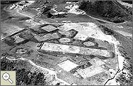
The first challenge faced by archaeologists is locating a site that will yield clues about the people who once lived there. To that end, several nondestructive methods can help determine whether a certain area may contain artifacts. If a site was once the home of a literate society, an archaeologist can often consult written records for possible clues. When documents are not available, the archaeologist can survey the area through careful observation of surface features and exposed artifacts. If the researcher discovers enough evidence, he or she can employ an arsenal of high-tech tools to explore a site further. One frequently used tool is aerial photography. Views from the sky offer unique perspectives on an archaeological site, often revealing features that might be less apparent from the ground. By carefully examining patterns of shadows, soil colors, and crop growth, an archaeologist may detect the remains of sunken features such as walls, ditches, and earthworks.
At ground level, a variety of remote sensing techniques can be used to investigate a site without disturbing it. Depending on a soil's composition, an archaeologist might use ground-penetrating radar, soil-resistivity testing (measuring a soil's electrical resistance),or magnetic surveys to determine the nature of the materials that lie below the surface. Ultimately, however, carefully directed digging in a site can reveal much more than all the nondestructive methods combined.
|
 |
 |
 |
 |

An aerial photograph of an excavation (Garrison Reservoir, North Dakota).
|
 |
 |
 |
|


|
|
|

